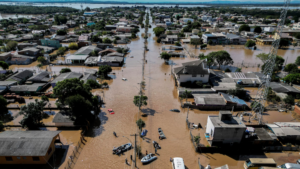
Researcher Sofia Royer Moraes with a group of local farmers and aid workers, created what is known as a Citizen Map, using Google Maps as a platform for ordinary people using their smartphones to pinpoint the floodwaters’ reach. These so-called citizen scientists were instructed to take photos of what they saw and send them, along with their geolocation, to a WhatsApp group monitored by Moraes and her team. Combining that information with historic flood data from the area, the team could model what might happen during future floods, helping residents who had already lost everything to decide where it would be safest to rebuild their lives. The models could also give authorities the information they needed for better urban planning and allocation of resources.
In the context of climate change, the team behind the Citizen Map wants Brazilian authorities to use this data to rethink everything from urban planning and post-disaster recovery to the availability of health care and clean drinking water in the aftermath of climate-change-induced catastrophes…